파일:Tembin Aug 20 2012 0235Z (alternate).jpg

문서 내용이 다른 언어로는 지원되지 않습니다.
위키뉴스

원본 파일(5,200 × 6,800 픽셀, 파일 크기: 8.61 MB, MIME 종류: image/jpeg)

이 파일은 위키미디어 공용에 있으며, 다른 프로젝트에서 사용하고 있을 가능성이 있습니다. 해당 파일에 대한 설명이 아래에 나와 있습니다.

파일 설명

설명
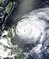
English: After four other Typhoons—Saola, Damrey, Haikui, and Kai-tak—made landfall in eastern China in just three weeks, Typhoon Tembin appeared ready to do the same. Tembin formed as a tropical depression over the western Pacific Ocean on August 19, 2012, and strengthened to a typhoon the next day.

The Moderate Resolution Imaging Spectroradiometer (MODIS) on NASA’s Terra satellite captured this natural-color image on August 20. Sporting a well-defined eye, Tembin hovered over the ocean just east of the Philippine island of Luzon. Although next to the Philippines, Tembin was not actually forecast to make landfall there. The U.S. Navy’s Joint Typhoon Warning Center (JTWC) forecast that Tembin would head northward before turning west and coming ashore in Taiwan and China. Focus Taiwan News Channel reported that Tembin might make landfall on Taiwan’s east coast on August 23.

The same day that MODIS took this picture, the JTWC reported that Tembin was a powerful storm. Located about 320 nautical miles (595 kilometers) northeast of Manila, Tembin had maximum sustained winds of 95 knots (175 kilometers per hour) and gusts up to 115 knots (215 kilometers per hour). Over the next 36 hours, Tembin was expected to strengthen, developing maximum sustained winds of 120 knots (220 kilometers per hour) and gusts up to 145 knots (270 kilometers per hour).
날짜
출처 http://lance-modis.eosdis.nasa.gov/wms/?zoom=5&lat=-16.87793&lon=160.16895&layers=B0000FFFFT&datum1=08/20/2012
저자 LANCE MODIS Rapid Response Team at NASA.
저작권
(이 파일을 인용하기)

Public Domain

Public domain 이 파일은 NASA에서 제작하였으므로 퍼블릭 도메인입니다. NASA의 저작권 정책에 따르면 NASA의 자료는 명시하지 않는 이상 저작권의 보호를 받지 않습니다. (Template:PD-USGov, 또는 NASA 저작권 정책 문서, JPL 그림 사용 정책을 참고하세요.)
주의사항:

설명

이 파일이 나타내는 바에 대한 한 줄 설명을 추가합니다

이 파일에 묘사된 항목

다음을 묘사함

파일 역사

날짜/시간 링크를 클릭하면 해당 시간의 파일을 볼 수 있습니다.

날짜/시간섬네일크기사용자설명
현재2012년 10월 29일 (월) 21:562012년 10월 29일 (월) 21:56 판의 섬네일5,200 × 6,800 (8.61 MB)Earth100Best Image
2012년 8월 20일 (월) 14:212012년 8월 20일 (월) 14:21 판의 섬네일5,604 × 6,729 (10.04 MB)Earth100

다음 문서 1개가 이 파일을 사용하고 있습니다:

이 파일을 사용하고 있는 모든 위키의 문서 목록

다음 위키에서 이 파일을 사용하고 있습니다:

메타데이터