
파일:Noord-Brabant position.svg

SVG 파일의 PNG 형식의 미리보기 크기: 200 × 236 픽셀. 다른 해상도: 203 × 240 픽셀 | 407 × 480 픽셀 | 651 × 768 픽셀 | 868 × 1,024 픽셀 | 1,736 × 2,048 픽셀
원본 파일 (SVG 파일, 실제 크기 200 × 236 픽셀, 파일 크기: 158 KB)
파일 설명
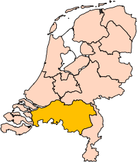
| 설명 | Location of the province of Noord-Brabant (North Brabant) in the Netherlands. |
| 날짜 | |
| 출처 | Own work, based on freely available GIS data |
| 저자 | User:Mtcv |
| 저작권 (이 파일을 인용하기) |
Data: attribution required; my work: PD |
| 다른 버전 | I attempted to make an svg version of Image:Noord Brabant-Position.png (with less simplified boundaries) |
Clickable version

라이선스

|
이 파일의 저작권자인 Centraal Bureau voor de Statistiek은 저작권자를 명시하는 조건에 따라 누구에게나 어떤 목적으로든지 제한 없이 사용할 수 있도록 허용하였습니다. 재배포나 이차적 저작물 작성 및 상업적 이용 등이 허용됩니다. |
|
|
| 주석 | 이 이미지에는 주석이 있습니다: 공용에서 주석을 보기 |


파일 역사
날짜/시간 링크를 클릭하면 해당 시간의 파일을 볼 수 있습니다.
| 날짜/시간 | 섬네일 | 크기 | 사용자 | 설명 | |
|---|---|---|---|---|---|
| 현재 | 2019년 3월 3일 (일) 02:20 | | 200 × 236 (158 KB) | Thayts | update |
| 2006년 10월 3일 (화) 09:49 |  | 200 × 236 (158 KB) | Mtcv | {{Information| |Description=Location of the province of Noord-Holland (North Holland) in the Netherlands. |Source=Own work, based on freely available GIS data |Date=2006-10-03 |Author=User:Mtcv |Permission=Data: attribution required; my work: PD |othe |
이 파일을 사용하는 문서
이 파일을 사용하는 문서가 없습니다.
이 파일을 사용하고 있는 모든 위키의 문서 목록
다음 위키에서 이 파일을 사용하고 있습니다:
- ar.wikipedia.org에서 이 파일을 사용하고 있는 문서 목록
- شمال بربنت
- آيندهوفن
- بريدا
- بارله ناساو
- تيلبورخ
- سيرتوخيمبوس
- قالب:بلديات شمال برابنت
- آلبورخ
- ألفن- كام
- أستن
- بيرخ آيك
- فيلدهوفن
- بيرخن أوب زووم
- بيرنهيزه
- بيست (هولندا)
- بلادل
- بوكل
- بوكسمير
- بوكستل
- كرانندونك
- كاوك
- دورنه
- دونجن
- دريميلين
- إيرسل
- إيتن- لور
- خيرتراودنبيرخ
- خيلدروب- ميرلو
- خيميرت- باكل
- خيلزه آن راين
- خورلا
- خرافه (هولندا)
- هارن (شمال برابنت)
- هالدربيرخه
- هيزه- لينده
- هيلموند
- هوسدن
- هيلفارينبيك
- لاربيك
- لانديرد
- لوب أوب زند
- مل آن سينت هوبرت
- موردايك
- نونن (خيرفن آن نيدرفيتن)
- أويرشخوت
- أويسترفايك
- أوسترهاوت
- أوس (هولندا)
- روسل- دي ميردن
- روسيندال
이 파일의 더 많은 사용 내역을 봅니다.